Chart in Focus becomes “Map in Focus” today as our Data Investigations Team looks at a newly released geospatial dataset.
In July, Google released a new dataset called Open Buildings, showing the estimated ‘footprints’ of 516 million buildings across Africa. The data was generated from satellite imagery by a machine learning algorithm – a technique sometimes referred to as artificial intelligence or AI.
As well as being an advert for Google’s new office in Accra, Open Buildings is billed as a resource to support academics and other researchers in work ranging “from population estimation, urban planning and humanitarian response, to environmental and climate science.” Could it be of use in monitoring deforestation in Africa’s tropical forest regions? And what are the ethical and political implications of this kind of continent-scale surveillance?
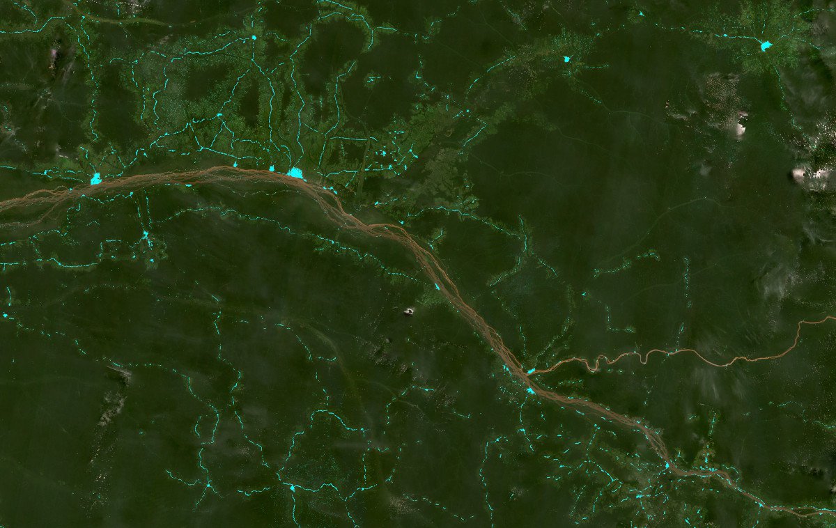
Buildings (bright blue) detected in towns and villages in northern Democratic Republic of Congo
The algorithm isn’t perfect: compared to the human eye it has trouble recognising unusually large buildings such as hangars and warehouses, buildings with complex roof structures, clusters of buildings that are very close together, and buildings that are partially covered by natural features like trees. But, importantly, it is able to detect buildings in remote areas as well as those in towns and cities, which the human eye might be drawn towards. Set the algorithm going and it will, in theory, discover a temporary structure deep within the Congo rainforest or the Sahara desert as readily as a villa in the sprawling suburbs of Lagos.
At first glance, Open Buildings seems ideal for tracking the encroachment of human activity into forests. Overlaying Google’s building outlines on free satellite imagery provided by Planet Labs and the Norwegian government shows development extending from towns and villages into dense areas of rainforest. Google’s algorithm detects buildings not only along roads and tracks, which are easy to identify anyway, but in forest clearings and other small open areas.
So far, so techno-utopian – but the Open Buildings dataset is also a document of global inequity
This is especially important in the Congo Basin, where 84% of forest disturbance between 2000 and 2014 can be attributed to small-scale, non-mechanised clearance for agriculture. Open Buildings’ use of high-resolution commercial satellite imagery makes it an ideal complement to lower-resolution deforestation data based on changes to the forest canopy, such as the University of Maryland’s GLAD alerts. If extended to other tropical forest regions, it could work in tandem with previous analysis conducted here at Global Witness, including efforts to map logging roads in the Solomon Islands and to track deforestation caused by cattle ranching in the Brazilian Amazon.
So far, so techno-utopian – but the Open Buildings dataset is also a document of global inequity. As Google’s technical report makes clear, data based on satellite imagery “can be particularly useful in developing regions where alternative data sources may be scarce”. Users in countries like the UK, by contrast, can rely on building footprints generated by well-resourced national mapping agencies such as Ordnance Survey, making Open Buildings look like a poor cousin by comparison.
As well as disparities in data quality and accuracy, there is a disjuncture in perspective. Scholars have long seen cartography and mapping as crucial components in the work of colonialism. As Silicon Valley giants expand their presence in Africa, does Google’s latest mapping project – based on satellite imagery sourced from companies whose business model relies on lucrative United States government contracts – risk replicating those dynamics?
Scholars have long seen cartography and mapping as crucial components in the work of colonialism
The company makes clear to potential users that work on Open Buildings “was led by Google Research, Ghana.” Yet of the ten co-authors listed on the accompanying pre-print, at least four – including two of the first three, conventionally those with the largest role in the research – work in Zürich, according to their LinkedIn profiles. Like international organisations doling out aid from Geneva, the Open Buildings dataset may be the result of looking at Africa from a perspective that is formally neutral but for practical purposes anchored in the Global North.
A counterpoint to the view from 400 miles above the Earth’s surface is suggested by the Missing Maps project, which connects data from OpenStreetMap – a collaborative map produced by volunteers all over the world – with people in underserved areas. The project still relies on satellite imagery for the initial identification of roads, buildings and other features, but the work of locals to add things like neighbourhood and street names makes the resulting data practically useful, particularly in high-pressure situations like natural disasters.
Open Buildings is still an important dataset. On the Data Investigations Team at Global Witness – an organisation no less implicated in these problems of perspective – we have already started integrating it into our deforestation analysis workflows. But as advances in satellite technology and computational analysis further enable this kind of planetary view, we should remain mindful of where exactly we are looking from and who stands to benefit from the knowledge created.Author
Related to Chart in focus
-
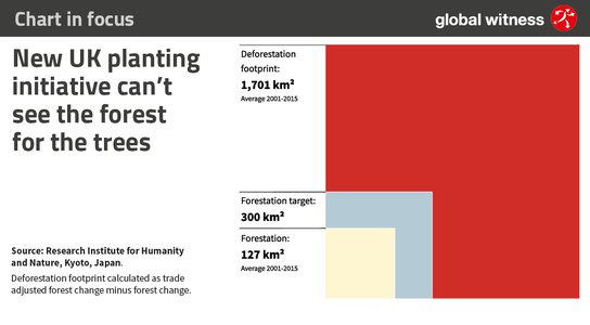
Blog Post | July 02, 2021 Chart in focus: New UK planting initiative can't see the forest for the trees
-
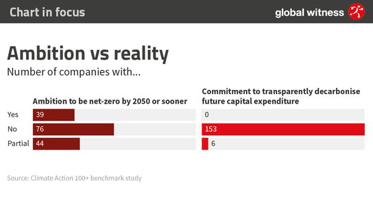
Blog Post | May 26, 2021 Chart in focus: New data shows that the world’s biggest polluters are still failing to put their money where their mouth is
-
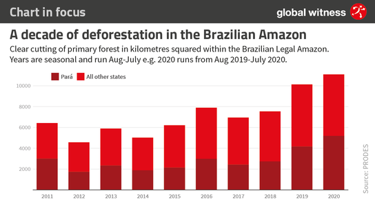
Blog Post | February 17, 2021 Chart in focus: New data shows deforestation in the Brazilian Amazon at 12 year high